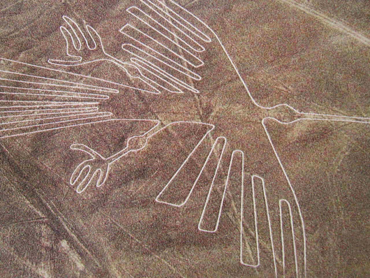
- The Nazca Lines ( Peru ) :
The Nazca Lines are a series of ancient geoglyphs located in the Nazca Desert in southern Peru. The high, arid plateau stretches more than 80 kilo-metres (50 miles) between the towns of Nazca and Palpa on the Pampas de Jumana , about 400 km south of Lima. Although some local geoglyphs resemble Paracas motifs such as wavy lines, triangles, spirals and rectangles. Scholars believe the Nazca Lines were created by the Nazca culture between 400 and 650 AD. Scratched on the ground, they number in the thousands and depict creatures from both the natural world and the human imagination. They include animals such as the spider, hummingbird, monkey, lizard, pelican and even a killer whale. Also depicted are plants, trees, flowers and oddly shaped fantastic figures.
 The Intensive study of the geoglyphs and comparison with other manifestations of contemporary art forms suggests that they can be divided into three chronological phases. The first dates from the Chavín period (500-300 BC) and is characterized by the technique of forming figures by piling stones. This was an important time of cultural developments in the Andean region, with strong influence exerted in the Inca region from the north by the Formative Middle Late Culture. The local development known as Paracas represents the second phase (400-200 BC), again strongly influenced from the north. The town of Paracas adapted its culture skilfully to its severe location and achieved a high level of artistic development.
The third phase, which represents the great majority of the geoglyphs, is the Nazca phase proper (200 BC-AD 500). The Nazca culture derived directly from that of Paracas. The Andean towns developed a powerful religious system which produced, along with Moche on the northern coast of Peru, an outstanding culture represented by its handicrafts notably pottery and textiles. Most of the geoglyphs of this period are located close to villages of this culture, such as La Quebrada del Frayle, Cahuachi, Palpa and Ingenio, concentrated in Pampa de Jumana.
Contrary to the popular belief that the lines and figures can only be seen with the aid of flight, they are visible from atop the surrounding foothills. The first mention of the Nazca lines in print was by Pedro Cieza de León in his book of 1553, where he mistook them for trail markers. Interest in them lapsed until the Peruvian archaeologist Toribio Mejia Xesspe spotted them while he was hiking through the foothills in 1927. He discussed them at a conference in Lima, Peru in 1939, although it must be added that although some of the figures can be worked out from the surrounding foothills the full designs cannot be truly appreciated unless viewed from the sky.
Paul Kosok, a historian from Long Island University, is credited as the first scholar to seriously study the Nazca Lines. He was joined by Maria Reiche, a German mathematician and archaeologist to help figure out the purpose of the Nazca Lines. They proposed one of the earliest reasons for the existence of the figures: to be markers on the horizon to show where the sun and other celestial bodies rose. Archaeologists, historians and mathematicians have all struggled to determine the purpose of the lines, but still there are several of the lines and many of them have remained unsolved.
- Teotihuacan ( Mexico) :
Teotihuacan also known as the City of the Gods, was a pre-Columbian Meso-american city located in the Basin of Mexico, 48 km (30 mi) northeast of modern-day Mexico City, which is today known as the site of many of the most architecturally significant Meso-american pyramids built in the pre-Columbian Americas. Teotihuacan is home to some of the largest ancient pyramids in the world. According to legend, it was here where the gods gathered to plan the creation of man. Teotihuacan Pyramids, was built beginning around 300 BC as the centerpiece of an enormous city, often compared to ancient Rome. They were inexplicably abandoned centuries before the arrival of the Aztecs, who called the ancient architectural marvel the "Birthplace of the Gods."
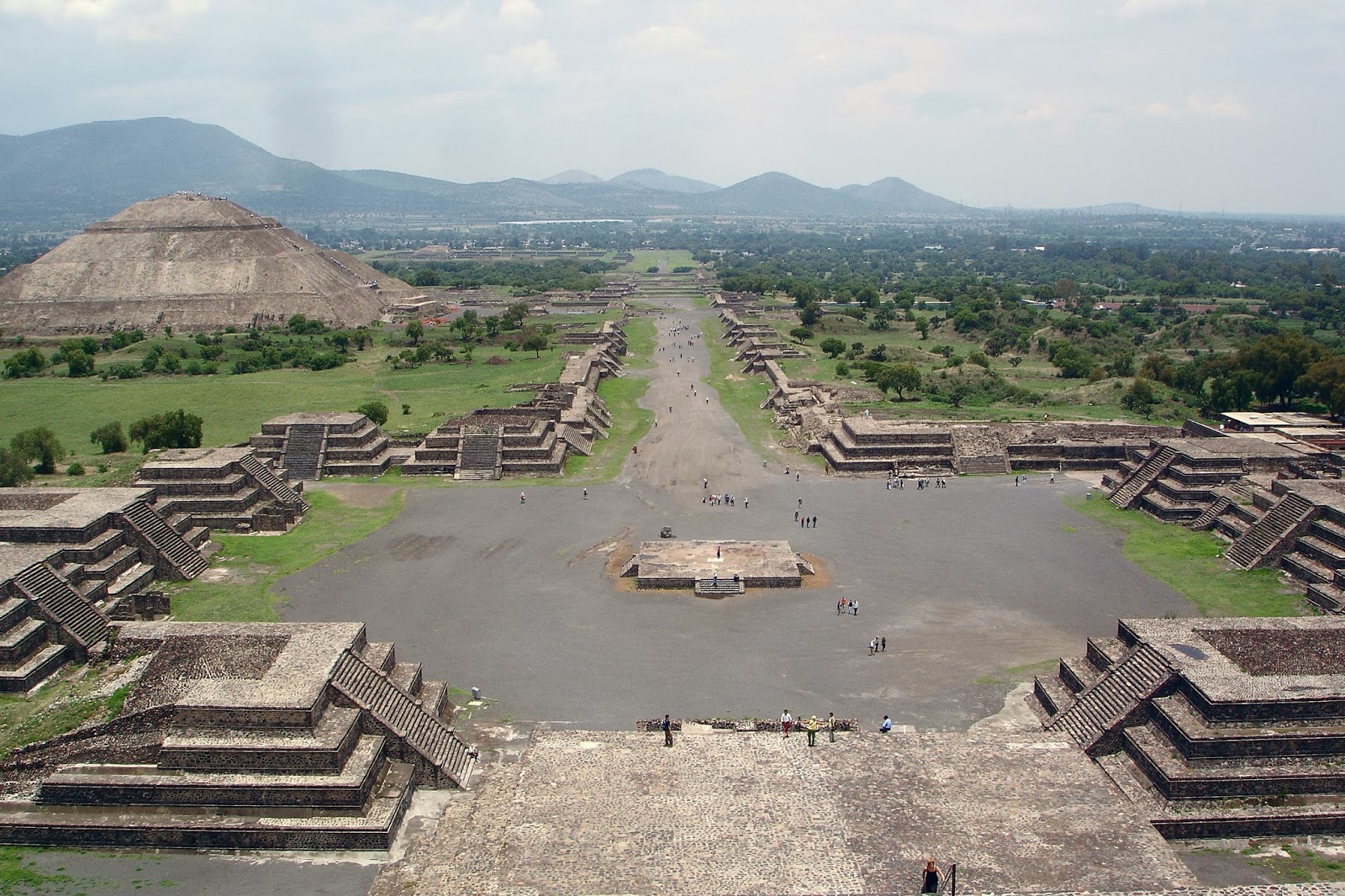 The city is thought to have been established around 100 BC and continued to be built until about AD 250. The city may have lasted until sometime between the 7th and 8th centuries AD. At its zenith, perhaps in the first half of the 1st millennium AD, when it went into a period of decline, including a fire that caused great damage. However, even with the decline, the city was never truly lost. Teotihuacan was the largest city in the pre-Columbian Americas, with a population of perhaps 125,000 or more, placing it among the largest cities of the world in this period. Neither they, nor modern archaeologists, have been able to unravel the secrets of these massive ruins, presided over by the third-largest pyramid in the world. Constructed according to precise astronomical measurements, and filled with the bodies of sacrificial victims, it was perhaps a place where bloody rituals were performed to keep the end of the world at bay. But no one really knows why.
The city was organized using a grid plan, many people living in what scholars refer to as “apartment compounds,” containing multiple families. An archaeological mapping project identified about 2,200 of these structures within the city, with excavations showing that some compounds were richer than others, containing more stone and lime plaster in their construction.
The site covers a total surface area of 83 square kilometres (32 sq mi) and was designated a UNESCO World Heritage Site in 1987.
- Bermuda Triangle :
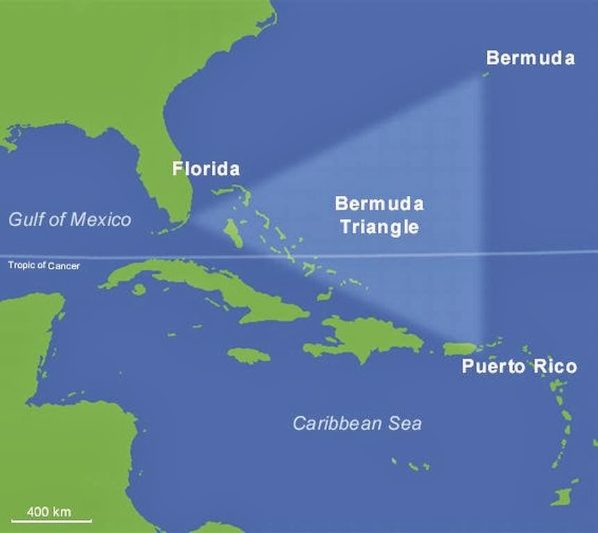 The Bermuda Triangle (also known as the Devil's Triangle) is an area bounded by points in Bermuda, Florida and Puerto Rico where ships and planes are said to mysteriously vanish into thin air — or deep water. Legend has it that many people, ships and planes have mysteriously vanished in this area. How many have mysteriously disappeared depends on who is doing the locating and the counting. The size of the triangle varies from 500,000 square miles to three times that size, depending on the imagination of the author. (Some include the Azores, the Gulf of Mexico, and the West Indies in the "triangle.") Some trace the mystery back to the time of Columbus. Even so, estimates range from about 200 to no more than 1,000 incidents in the past 500 years. Howard Rosenberg claims that in 1973 the U.S. Coast Guard answered more than 8,000 distress calls in the area and that more than 50 ships and 20 planes have gone down in the Bermuda Triangle within the last century.
Charles Berlitz, whose family created the popular series of language instruction courses, also had a strong interest in the paranormal. He believed not only that Atlantis was real, but also that it was connected to the triangle in some way, a theory he proposed in his bestselling 1974 book "The Bermuda Triangle." The mystery has since been promoted in thousands of books, magazines, television shows, and websites.
Over the years, many theories have been offered to explain the mystery. Some writers have expanded upon Berlitz's ideas about Atlantis, suggesting that the mythical city may lie at the bottom of the sea and be using its reputed crystal energies to sink ships and planes. Still others believe that the explanation lies in some sort of extremely rare and little known , yet perfectly natural, geological or hydrological explanation. For example, perhaps ships and planes are destroyed by pockets of flammable methane gas known to exist in large quantities under the sea. Maybe lightning or an electrical spark ignited a huge bubble of methane that came to the surface right next to a ship or plane, causing them to sink without a trace. Other more fanciful suggestions include time portals (why a rift in the space-time fabric of the universe would open up in this particular patch of well-traveled ocean is never explained) and extraterrestrials including rumors of underwater alien bases or possibly alien activity or UFO. There are a few obvious logical problems with this theory, including that methane exists naturally around the world and such an incident has never been known to happen.
Even though, Popular culture has attributed various disappearances to the paranormal or activity by extraterrestrial beings. Documented evidence indicates that a significant percentage of the incidents were spurious, inaccurately reported, or embellished by later authors. In a 2013 study, the World Wide Fund for Nature identified the world’s 10 most dangerous waters for shipping, but the Bermuda Triangle was not among them. Contrary to popular belief, insurance companies do not charge higher premiums for shipping in this area.
- Stonehenge :
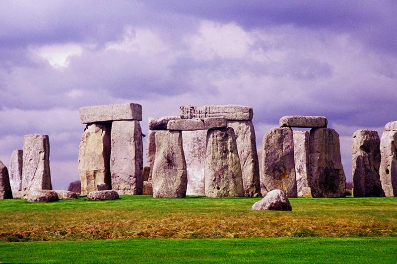 Stonehenge is a prehistoric monument in Wiltshire, England. One of the most famous sites in the world, Stonehenge is the remains of a ring of standing stones set within earthworks. It is in the middle of the most dense complex of Neolithic and Bronze Age monuments in England, including several hundred burial mounds.Archaeologists believe it was built anywhere from 3000 BC to 2000 BC. Radiocarbon dating in 2008 suggested that the first stones were raised between 2400 and 2200 BC, whilst another theory suggests that bluestones may have been raised at the site as early as 3000 BC. Its purpose continues to be a mystery. The biggest of its stones, known as sarsens, are up to 30 feet (9 meters) tall and weigh 25 tons (22.6 metric tons) on average. It is widely believed that they were brought from Marlborough Downs, a distance of 20 miles (32 kilometers) to the north. Smaller stones, referred to as bluestones (they have a bluish tinge when wet or freshly broken), weigh up to 4 tons and most of them appear to have come from the Preseli Hills in western Wales, a distance of 156 miles (250 km). It’s unknown how people in antiquity moved them that far; water transport was probably used for part of the journey. Recently, scientists have raised the possibility that during the last ice age glaciers carried these bluestones closer to the Stonehenge area and the monument’s makers didn’t have to move them all the way from Wales. Archaeological evidence found by the Stonehenge Riverside Project in 2008 indicates that Stonehenge could have been a burial groundfrom its earliest beginnings. The dating of cremated remains found on the site indicate that deposits contain human bone from as early as 3000 BC, when the ditch and bank were first dug. Such deposits continued at Stonehenge for at least another 500 years. Recent research suggests that up to 240 people were buried in total, making Stonehenge the large Neolithic burial site in Britain. The site is a place of religious significance and pilgrimage.
- Cahokia ( USA ) :
Cahokia is located on the site of an ancient Native American city situated directly across the Mississippi River from modern St. Louis, Missouri ( 600–1400 CE) . Cahokia was a city that, at its peak from 1050-1200 A.D., was larger than many European cities, including London. The city spread out over six square miles (16 square kilometers) and encompassed at least 120 mounds and a population between 10,000 and 20,000 people. It was the largest pre-Columbian city north of Mexico. The inhabitants of Cahokia did not use a writing system, and researchers today rely heavily on archaeology to interpret it.
Cultural finds from the city include evidence of a popular game called 'Chunkey' and a caffeine loaded drink. Artistic finds include stone tablets carved with images (such as a birdman) as well as evidence of sophisticated copper working, including jewelry and headdresses.
The city fell into decline after 1200 A.D., becoming abandoned by 1400. The name “Cahokia” is from an aboriginal people that lived in the area during the 17th century.
Much of the city lies buried under 19th and 20th-century developments, including a highway and the growth of the city of St. Louis.
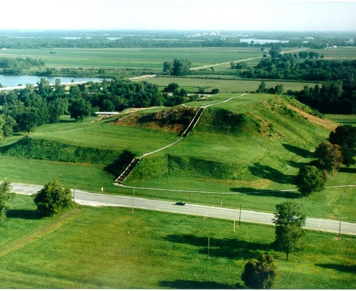
The most beautiful example of architecture at Cahokia is the 100 foot tall 'Monks Mound' the name given to it because a group of Trappist monks lived near it at that time.
It was built with four terraces, covering about 17 acres (6.8 hectares) at its base, the mound towering over the city. Archaeologists have found giant post-holes at the top indicating the presence of a temple,made of wood, measuring 104 feet by 48 feet width. Its postholes are over 3 feet in diameter, the building being about 50 feet tall.
Monks Mound, along with a grand plaza and a group of smaller mounds, was walled in with a 2-mile-long (3.2 km) wooden palisade. As many as 20,000 wooden posts were used to construct it.
To the west of Monks Mound is a series of five circles, each originally made of red cedar wood posts, constructed at different times between 900 and 1100 A.D. They vary in size from 12 to 60 posts, the latest one being the smallest. Archaeologists refer to these structures as a wood-henge.
These posts would likely have been used as a calendar of sorts marking the solstices, equinoxes and festivals important to the inhabitants. A priest could have stood on a raised platform in the middle.
The sunrise during the equinox, when it rises to the east, is said to be particularly spectacular from this spot. A post aligns with the front of Monks Mound and the massive structure looks like it gives birth to the sun.
Mound 72 is a 10-foot high structure located less than a half-mile south of Monks Mound. It dates between 1050 and 1150 and holds the remains of 272 people, the largest number of sacrificial victims ever found north of Mexico.
The mound’s archaeology is complicated but several instances of human sacrifice can be made out. In one case 39 men and women were executed on the spot, writes archaeologist Timothy Pauketat in his book. In another sacrifice, 52 malnourished women between the ages of 18 and 23 appear to have been sacrificed at the same time, along with a woman in her 30's. In another burial, 15 corpses, a mix of men, women and children, were found on wooden stretchers.
Curiously, this burial mound also has the remains of two men who were found buried with 20,000 shell beads, likely the remains of a garments. Analysis of their remains indicates that they consumed a large amount of meat, suggesting that they were elite members of Cahokia’s society, the human sacrifices at the mound possibly dedicated to them in some way.